“Putting it on the map” is an expression that essentially means “taking something unknown and making it famous or well-known.” This usually refers to some noteworthy event, person, recognition, location or somesuch, something that involves actual effort or achievement. Thanks to Google Maps, “putting something on the map” nowadays is a simple matter of a few clicks. Sometimes I wonder if it should really be that easy, or if I should do it at all.
Over the years I’ve added a number of pioneer or community cemeteries to Google Maps, or corrected their locations. Some, like the Yacolt Cemetery, are so obvious I don’t know why they weren’t already on the map. Others, like the Fir Grove aka Thompson Cemetery, are well off the beaten trail. Still others, such as the Wyeth aka Gorton-Gray Cemetery, Sunset Pioneer aka Tigard Evangelical Cemetery, the Deardorff Cemetery and the Chenowith Cemetery, are fairly accessible if you just know where to go. (I didn’t add the Deardorff, but I did add photos to the listings on Google Maps and Findagrave.) The smaller, older, and less accessible the cemetery, the greater my satisfaction at finding and mapping it.
When I first started being more diligent about photographing the pioneer cemeteries I visited, I believed (and still do) that my photos helped genealogy buffs know whether it was possible to visit these out-of-the-way cemeteries. If a chubby middle-aged woman like myself could make it there, then a retired, senior history buff probably could too. (And vice versa, if someone has posted a photo on Findagrave, I know it’s probably physically possible to get there.) I’m not a hard-core genealogist, so if someone else wanted to go there and measure the site and document the burials, more power to them.
The problem is, the listings also help vandals and other ill-intentioned people know whether it’s possible to visit these same sites. This was very much on my mind while visiting the ruins of the Chenowith Cemetery, which was essentially abandoned in the 1930s and badly vandalized in the 1970s (according to various sources). I debated whether to add the missing place to Google Maps. In the end I decided to, because “Chenowith Cemetery Road” was already there, and duh, it’s kind of obvious that a road with that name would go to a cemetery.
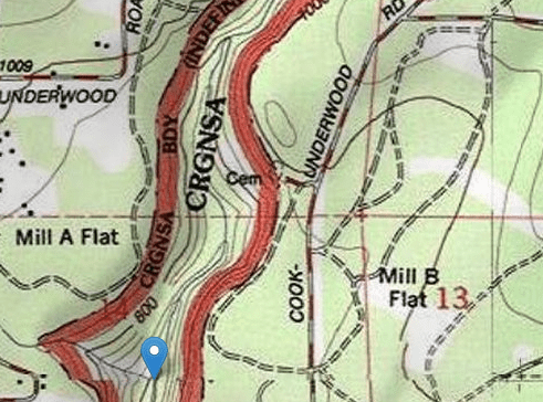
Besides, the Chenowith Cemetery had in fact been mapped previously, on US Forest Service and other maps.

This is what the cemetery site looks like today. There’s a small clearing surrounded by underbrush. A “no parking” signboard is next to Moroni Morby’s beautifully carved stone, which is very likely not in its original location.

Only a few stones are visible; there are surely others buried in the underbrush, and others were reportedly pushed off the nearby cliff toward the Little White Salmon River.
Given today’s political climate, the decision whether to photograph Jewish, Muslim or ethnic cemeteries gives me pause. I usually do if those cemeteries are already on the map and accessible. I have a policy of not visiting or photographing cemeteries on Native American land. And if someday, I find a tiny, abandoned, secret pioneer cemetery way out in the woods somewhere….I might just let that place and its residents rest in peace.
Stump and Lamb explores personal growth and meaning via travels to pioneer cemeteries of the West.
This post was originally published at michellerau.com.
